Ten Day Hikes in Sheridan County
The Bighorn Mountains offer some of the finest recreation opportunities in the nation, and there’s no lack for options when it comes to hiking – there are more than 1,500 miles of trails across the entirety of the range. You could set out on a grueling multi-day expedition into the backcountry of the Cloud Peak Wilderness, or take a casual stroll on a well-maintained walking path only a few miles from downtown – Sheridan County has hikes for all skill and experience levels. Here, we’ve collected 10 of our favorite day hikes, selected for their scenic beauty, relative ease, and convenient access.
For additional info on hiking in the Bighorn Mountains, check out these great resources, available at shops across Sheridan County:
Hiking Wyoming’s Bighorn Mountains: A Guide to the Area’s Greatest Hiking Adventures by Ken Keffer
Hiking Wyoming’s Cloud Peak Wilderness: A Guide to the Area’s Greatest Hiking Adventures, by Erik Molvar
Bighorn National Forest Map, by U.S. Forest Service
Cloud Peak Wilderness Map (National Geographic Trails Illustrated Map, 720), by National Geographic Maps
1. STEAMBOAT POINT
Difficulty: Moderate
Length: 1.7 mi.
Estimated Time: 1 hr. 11 min.
Elevation Gain: 666 ft.
Route Type: Out & Back
Description: This arduous hike provides rewarding 360-degree views from the top of Steamboat Point.
Directions: From Burgess Junction Visitor Center
From the Visitor Center, turn left onto US-14 E and continue on this route for 11 miles until you see the pull off for Steamboat Point.
2. TONGUE RIVER CANYON
Difficulty: Moderate
Length: 4.7 miles
Estimated Time: 2 hr 13 min
Elevation Gain: 830 ft.
Route Type: Out & Back
Description: Tongue River Canyon comes off of state land near Amsden Creek Wildlife Habitat Area. This trail follows the Tongue River, winding through the sheer, limestone walled canyon. On top, beautiful views of tributary canyons, wildflower, and aspen clones, For Fishermen, The Tongue River is a great place to catch Browns and Rainbows.
Directions: From Burgess Junction Visitor Center
Turn Left onto US-14 E for 23.9 miles. Once in Dayton, take a left onto Tongue Canyon RD and follow the road until it dead ends at the trailhead.
3. PORCUPINE FALLS
Difficulty: Easy
Length: 0.8 mi
Estimated Time: 37 min
Elevation Gain: 360 ft.
Route Type: Out & Back
Description: A short yet steep descent down to the falls with a more steep climb on the way back out. This trail is worth the climb for many as it sports an impressive 100 ft. waterfall into a pool below.
Directions: From Burgess Junction Visitor Center
Turn Right onto US-14 W. Take a slight right onto US-14 W Alternative and follow for 20 miles. Turn Right onto Forest Service RD 13 and follow for 2 miles. Turn left onto Forest Service RD 137 and follow for about a half mile. Take a right off 137, and then another left onto Forest Service RD 14 and continue for about 2.5 miles. Finally, Follow Forest Service RD 14 until Forest RD 146 appears, and take a left. Remain on this road to find the trailhead.
4. PARADISE FALLS
Difficulty: Easy
Length: 2.6 mi.
Estimated Time: 1hr. 47 min.
Elevation Gain: 623 ft.
Route Type: Out & Back
Description: Located along US14 Alternative, Paradise Falls offers picturesque pools with plenty of flat granite to sit back, relax, and enjoy the views from.
Directions: From Burgess Junction Visitor Center
Turn right onto US-14 W and follow for about 1.3 miles. Take a slight right and merge onto US-14 Alternative W and follow for 15.2 miles. Turn Left onto Forest Service RD 121 until the trailhead is in sight.
5. BUCKING MULE FALLS
Difficulty: Moderate
Length: 4.9 mi.
Estimated Time: 1hr. 52 min.
Elevation Gain: 452 ft.
Route Type: Out & Back
Description: The trail is a long strenuous drop down into and out of Devil Canyon with an overlook for Bucking Mule Falls. Good for backpacking and horse trips.
Directions: From Burgess Junction Visitor Center
Turn right onto US-14 W and take a slight right onto US-14 Alternative in about 1.3 miles. Then, follow this road for about 20.2 miles. Turn onto Forest RD to continue for 2 miles. At this point, take a left turn onto Forest RD 137 and continue for about a half of a mile. Take the first available right turn off of 137 and take a left in half of a mile onto Forest RD 14 and continue on this road for 5 miles to Bucking Mule Falls Trailhead.
6. BLACK MOUNTAIN LOOKOUT
Difficulty: Strenuous
Length: 3.4 mi.
Estimated Time: 2 hr. 10 min.
Elevation Gain: 1,076 ft.
Route Type: Out & Back
Description: Located off of forest service road 222, Black mountain offers a scenic 360 degree lookout of the surrounding area. Bring plenty of water as this hike features a 1,076 ft. elevation gain with a rock scramble near the very end of the trail.
Directions: From Burgess Junction Visitor Center
Turn left onto US-14 E for 7.9 miles. Turn right onto Black Mountain RD and continue for 3.5 miles. Then Turn Left onto Forest RD 222 and continue to the Trailhead.
7. SOLDIER RIDGE
Difficulty: Moderate
Length: 8.1 mi.
Estimated Time: 3hr 13min.
Elevation Gain: 872 ft.
Route Type: Out & Back
Description: Located in the foothills of the Bighorns, this 8.1-mile, non-motorized trail offers beautiful 360-degree views and is located convenient to Sheridan. Bring a windbreaker during colder months and extra sunscreen and a hat during the summer as the trail follows the exposed ridge
Directions: From Sheridan
From Main Street Sheridan, take a right or left onto Fifth ST and follow for about 2.8 miles at which point take a right at the posted signage for Soldier Creek Trailhead.
8. SIBLEY LAKE
Difficulty: Easy
Length: 2.3 mi.
Estimated Time: 52 min.
Elevation Gain: 209 ft.
Route Type: Out & Back
Description: Sibley Lake is open to non-motorized craft and offers an accessible fishing dock on the shoreline. Anglers fish for rainbow, brown, and brook trout. Diverse hikes vary from loop trails to treks along creeks and over mountain peaks.
Directions: From Burgess Junction Visitor Center
Take a left onto US-14 E and continue for 4 miles. Then, turn right into Sibley Lake Campground and lake access.
9. STORY PENROSE TRAIL
Difficulty: Moderate
Length: 6.9 mi.
Estimated Time: 3 hrs. 46 min.
Elevation Gain: 1,709 ft.
Route Type: Out & Back
Description: Near Story, Wyoming. Story Penrose Trail offers an experience that can be had on foot or by ATV. Bring hiking shoes with ankle support, as this trek consists of pure elevation gain and spectacular points of interest.
Directions: From Sheridan
Head East on Fifth ST. to then merge onto I-90 south for 10 Miles. Take Exit 33 at Meade Creek RD. Turn right onto WY 342 W/ Meade Creek RD for 1.1 miles. Turn left onto US-87 S for 7.2 miles. Then Turn right onto Fish Hatchery RD for 2.6 miles. Lastly Turn right onto Penrose LN. to see the Trailhead.
10. WELCH RANCH
Difficulty: Easy
Property Size: 1700 acres
Estimated Time: N/A
Elevation Gain: N/A
Route Type: Loop
Description: Welch ranch offers a variety of activities for hunters, fishers, bikers, and hikers. Dispersed camping is allowed in the area, while the use of motorized vehicles and target shooting is prohibited.
Directions : From Sheridan
To reach Welch Ranch from Interstate 90, take exit 339 and head east. Go over the railroad tracks and turn left (north) onto WY 338. Go about 5.5 miles. The first parking area will be on your left, just before the Tongue River, and the second parking area will be on the right, just after the river.
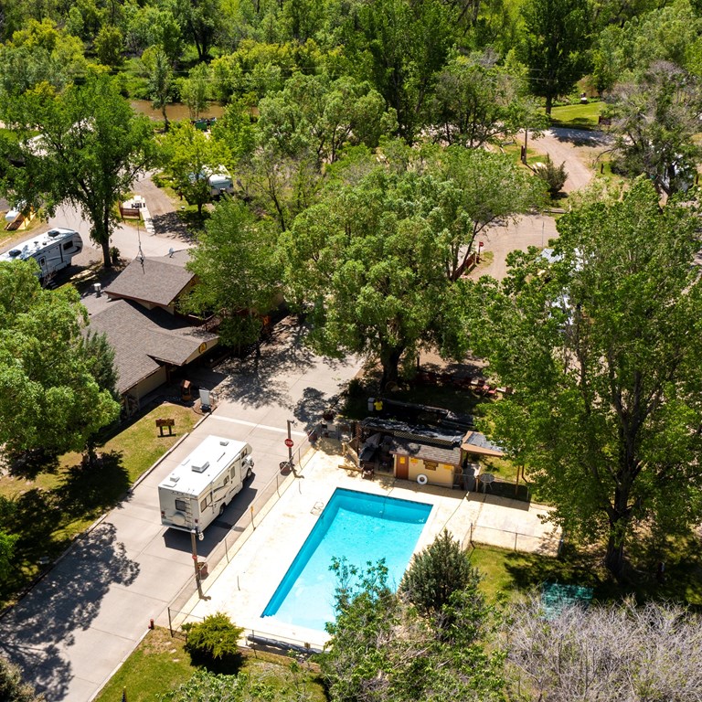
RESERVE A CAMPSITE AT THE SHERIDAN / BIG HORN MOUNTAINS KOA JOURNEY TODAY
Sheridan / Big Horn Mountains KOA Journey is a camping paradise that seamlessly combines the spirit of the Old West and the beauty of nature, modern amenities, and endless adventures. The campground has everything you need, whether your trip is a quick weekend getaway or a week-long vacation. It’s a convenient location between Mt. Rushmore and Yellowstone National Park. This KOA location offers Pull-Thru or Back-In RV Sites. Most of our sites are full hookups and every site has 50, 30 or 20 amp service. If you do not have an RV or want a more luxurious camping experience, consider staying in one of our Deluxe or Camping Cabins or even a Conestoga Covered Wagon with a private bath house! If you want a truly authentic camping trip, you can camp at one of the Tent Sites. We also now offer RV rentals through our partnership with RVshare. We also have extended stay and group stay options to get the most out of your camping experience. You can also enjoy your stay here by exploring our uniquely Wyoming gift store, calf roping demonstrations, mini golf, fishing Goose Creek, and our gem mining sluice!
If you want to experience great camping and the spirit of the Old West at the same time, the Sheridan Big Horn Mountains KOA is the perfect campgrounds for you and your family! Reserve a campsite today!