Fishing
Siskiyou County remains a premier destination for fishermen. The McCloud River is famous the world over for its spirited, gorgeous redband trout, and the Upper Sacramento River remains a favorite for its miles and miles of easy access.The Klamath River's steelhead still quicken the pulse, and a variety of other rivers, small streams, reservoirs and alpine lakes attract conventional and fly fishermen alike.Fishing, When it comes to fishing there are very few places prettier than Siskiyou County.Fishing Out on the lake, photo © Mark GibsonWorld-class trout fishing has made Southern Siskiyou County a favorite destination for fishermen. Wild rivers and streams feature both wonderful riffles and deep pools suitable for waders or bank fishermen. High mountain lakes offer clear water and plenty of fish both summer and winter. The Mt. Shasta Fish Hatchery, one the oldest operating hatcheries in the West, plants trout in the nearby lakes and streams. To fish you must have a current California Fishing License in full view and be familiar with Dept. of Fish and Game regulations. Local regulations and limitations may apply to specific streams.Lake FishingLakes are open all year although some are inaccessible during winter months. Many lakes contain wild trout and are also stocked with hatchery-raised trout.
 Lake fishing, photo © Mark GibsonLake Siskiyou — From the central Mt. Shasta exit off I-5, turn west to stop sign at Old Stage Rd. and turn left. Keep right onto W. A. Barr Rd. to Lake Siskiyou about 3 miles west of Mount Shasta. Fed by five clear, mountain streams, Lake Siskiyou's 430 acre recreational waters are held by Box Canyon Dam at the south end. Boat fishing and trolling is great any time of year with speeds limited to 10 mph. Lake Siskiyou Camp Resort, 3 miles west of Mount Shasta on W. A. Barr Rd., offers a boat ramp with marina, boat rentals, and free fish cleaning station. North Shore Road off W. A. Barr Rd. is an unpaved road leading to several fishing access areas. Please park in designated areas. The lake offers Rainbow, Brown trout, Bass and Crayfish. Anglers bait options may include power bait (red, orange, green, rainbow or sparkle), nightcrawlers, garlic marshmallow and salmon eggs. Try a “smorgasbord” of marshmallow and worm on one hook. Use a sliding sinker above a BB line weight 18 inches from your hook and bait.Boat trolling from January to June produces 18 inch natives. Best lures are rapalas, rebels, broken back, black, silver, and small trout imitations. Also try black & green wooly buggers, bingo bugs, humdingers, ford fenders with worm. Lines for early season trolling should be 10-15 feet below surface. After mid-July, drop lures to 15-35 feet to colder waters.Castle Lake — From I-5 central Mt. Shasta exit, follow directions to Siskiyou Lake. Cross Box Canyon Dam and turn left onto Castle Lake Rd. and drive 7 miles to the lake at end of road at 5200' elevation. Formed by glaciers 10,000 years ago, Castle Lake is held by a pine-covered granite bowl. This 47 acre lake is 120 feet deep next to a steep rock wall. Above the lake are the beautiful lofty spires of Castle Crags State Park Wilderness Area.You'll find gold shiners, brook and rainbow trout. Best baits are salmon eggs, roe, mini-crawlers, red worms and bright-colored power bait. Ice fishing during the winter is truly rewarding lifetime experience. Break the ice for fishing holes with an auger, axe or shovel. Dress warmly and bring a lawn chair. Check with the Mt. Shasta Forest Service Ranger office (530) 926-4511 for road conditions and ice conditions. Ice skaters enjoy the lake also. Take your camera to capture a spectacular view of Mt. Shasta on the road's Vista Point turnout. A Forest Service campground located about 1/2 mile down the road is open during the summer. No camping is allowed next to lake due to the sensitive alpine ecology and bank erosion.
 Lake fishing, photo © Mark GibsonGumboot Lake — From the central I-5 Mt. Shasta exit, follow directions to Lake Siskiyou on W. A. Barr Rd. Continue past the lake on paved South Fork Rd. for about 15 miles. Bear left at Gumboot Lake entrance sign at 6050' elevation.A high alpine lake on south slope of Mt. Eddy, Gumboot Lake is 7 acres and about 18 feet deep. This reedy lake is rimmed by a grass shore and pine trees. A Forest Service campground is available with 3 sites but no running water. A great place for a family outing. Stocked with rainbow trout, the fly fishing is very good at times. No motor boats are allowed but it is easily fished from the shore. There is no winter access due to snow on the road. Check conditions and access with the Forest Service in early summer as the ice can linger into June at higher alpine lakes.McCloud Reservoir — Take Hwy. 89 to McCloud. Turn right (south) onto Squaw Valley Rd. Drive 10 miles to Lake McCloud boat ramp or continue to the Lake McCloud Dam. Held by a large dam, Lake McCloud is deep, incredibly blue/green and very cold. McCloud River's clear waters flow into the lake at the north end. Steep banks and scarce parking areas make shore angling challenging, although dam reached by the lakeshore road is easily accessible and productive. Boat fishing is recommended both winter and summer. A public boat ramp and boat trailer parking area is at the Squaw Valley Road approach to the lake. Troll deep during the warm summer months with bait or lures.Lake Shastina — From Mount Shasta, drive 8 miles north on I-5 to Weed central exit. Turn right onto Weed Blvd., then right onto Hwy. 97. Continue to Lake Shastina Golf Course sign; then turn left onto Big Springs Rd. Turn left onto Jackson Ranch Rd., then right at fishing access sign to the lake.Lake Shastina offers a public boat ramp and limited bank fishing. Surrounded by private property, permission for fishing access has not been granted by property owners. Shoreline is rocky with sagebrush. As an agricultural irrigation reservoir, Lake Shastina can drop significantly by the end of summer.Fishing is best by boat. You can fish for a wide variety including trout, bass, crappie and catfish.Sacramento RiverTo preserve the ecosystem of the river, please observe these special fishing regulations. You must:
- Use barbless hooks or artificial lures. Barbless hooks can be made by pinching down barbed hooks.
- Observe zero limit – catch and release. To release a fish, gently hold it upside-down underwater and remove the hook. If the hook is swallowed, simply cut the line and release the fish.
- Carry a visible fishing license.
Always wear good fishing or wading shoes and light clothing. You may not need waders, but watch your step as the rocks can be slippery. Since the water is cold, watch for hypothermia on cool days.

Catch of the day, photo © Mark Gibson
Cantara LoopZero limit: catch & release
Drive south on Old Stage Rd. from Lake St. and turn right on unpaved Cantara Rd. to access parking at bottom of hill. A beautiful rocked-walled canyon with deep pools, rapids and riffles to challenge your fishing skills. Fish the immediate area or walk along the banks.Dunsmuir Access Points
Limit: Five trout; barbed hooks
Catch & keep area extends in Dunsmuir from Scarlet Way bridge to the mouth of Soda Creek near Castle Crags State Park.Within the Dunsmuir city limits are a variety of fishing access areas easily reached by car and a short walk. Many can be fished both from the bank and in the river.In Dunsmuir, you may keep 5 fish. Anglers may use flies, lures or bait with barbless hooks and occasionally catch 20 inch rainbow trout. Remember, these fish are big because they are smart. Fish the riffles and pocket water behind rocks. Get the bait down deep in both riffles and pocket pools. Learn to read the water, position your lure in the river so it's attractive to a hungry fish. The big, wild rainbows like to observe and select the best food and will not grab every fishing lure or fly anglers toss in. “To catch fish, you need to think like a fish.”The upper Sacramento River watershed has been a treasure of many varieties of amphibians, reptiles, fish, birds and animals. Unfortunately in 1991, a railroad chemical spill killed most of the fish in the river. Through careful controls, natural recovery has been encouraged and the wide diversity of life is being reestablished quickly. You are invited to tour the Sisson Museum in Mount Shasta to see a large wall mural depicting the ecosystem of the river.Precaution: The railroad follows the river canyon, so please use caution when walking on or near the tracks. Never climb through or under a stopped train as it may suddenly move.Soda Creek, Sacramento River
5 fish limit – barbless hooks only.
Take Soda Creek exit off I-5 which is about 3 miles south of Dunsmuir. Anglers can catch and keep fish only to the mouth of the Soda Creek.Castella, Sacramento River
Zero Limit: Barbless flies or lures only.
Cross bridge to east side of river about 6 miles south of Dunsmuir. Riffles and small pools within Castle Crags State Park which offers picnic facilities and fine hiking trails. Foot bridge over river. The Crags are 225 million years old.Sweetbriar, Sacramento River
Zero limit: barbless flies or lures only.
Take Sweetbriar Exit off I-5 about 8 miles south of Dunsmuir. Walking on the big boulders requires good balance and sure footing. You can walk down the railroad tracks and wade back up the river fishing the riffles and pot holes behind the rocks. Use wet-weighted flies to work base of rip-rap.McCloud River
The McCloud River is the most popular attraction on the district. Fishing, swimming, camping and spectacular scenery are among the many attractions offered along the river. The McCloud River is the only fishery in California which supports the now rare Bull Trout, also know as the Dolly Varden Trout. Actually a member of the Char family, it is found between Lower Falls and Shasta Lake. Because it is considered an endangered species by the State of California, it must be released if caught.Lower Falls, McCloud River
5 fish limit, barbed hooks.
5 miles east of McCloud off Highway 89 at Fowlers Campground. Spectacular waterfall and deep pool with excellent fishing in riffles and rapids above and below the falls. Stocked with Rainbow trout, German Brown trout and Brook trout. Watch your footing on loose rocks and steep rocky ledges. Pool is a swimming hole during the summer.Larkin Dam, McCloud River
5 fish limit, barbless hooks only.
From Hwy. 89 about 5 miles east of McCloud turn at Upper McCloud River Area sign. Turn left on unpaved River Loop Road to Lakin Dam sign. Follow signs to fishing access parking lot. Clear, cold water behind dam flows through reedy area providing excellent bank fishing. Wood fishing platform provides easy handicapped access near parking lot or take short trail to the dam. Good bird viewing area too.Cattle Camp, McCloud River
5 fish limit, barbless hooks only
11 miles east of McCloud off Hwy 89. Turn on Upper McCloud River Loop Road to Cattle Camp fishing access. Wide swimming hole and gravel bar “beach” provides easy access to river. Walk up or down river from there for more secluded fishing. Popular for summertime family outings. Restroom available plus picnic tables.Ash Camp, McCloud River
2 fish limit, single barbless hook, no bait.
From Lake McCloud, continue around the lake, cross the dam turning right on unpaved road for about 1 mile. Provides easiest access to the lower McCloud River but is difficult to wade both up and downstream. Not stocked below McCloud Dam to Lady Bug Creek.Ah-Di-Na, McCloud River
2 fish limit down to Lady Bug Creek, single barbless hook, no bait.
Follow the road around Lake McCloud. Follow road signs to Forest Service Ah-Di-Na campground. Fish deep when water has off-color. Get weighted wet fly down to fish by adding weight to leader. Fish the riffles and pools behind the rocks. Smart trophy fish will make your day exciting and challenging. The Preserve and An-Di-Na are on the site of an old Wintu Native American camp.McCloud River Preserve, McCloud River
Zero limit, single barbless hooks, artificial lures only. No bait.
Limited to 10 people a day, first-come, first-serve. From Hwy. 89 at McCloud, turn south on Squaw Valley Rd. to Lake McCloud and follow signs to Ah-Di-Na Campground. Park in campground and walk down the road and trail to the McCloud River Preserve Cabin near the river. There is no road into the Preserve. All wildlife is protected here through the Nature Conservancy. This area is famous for trophy-size Rainbow, Brown, and protected Dolly Varden trout. Ice fishing on Castle Lake, photo © Mark GibsonIce FishingSiskiyou County is a Winter Wonderland for the ice fisher. Just about eight miles from the City of Mt. Shasta, and about seven miles above Lake Siskiyou sits Castle Lake, one of the most beautiful lakes in the north state. In addition to its being a spectacularly beautiful spot, it's a great place to try your hand at ice fishing.Related BusinessesClick here for the list!
CA Dept of Fish and Wildlife
Mt Shasta, CA 96067
530-225-2300
Website


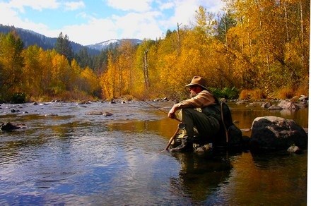
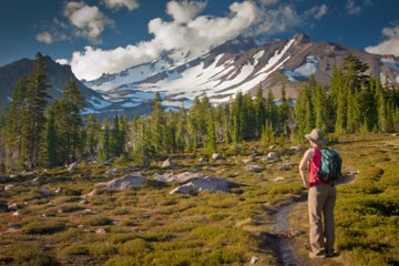
 Photo by Mark GibsonPopular Trails on Mt. ShastaSHORT HIKES (15-45 minutes)John Everitt Vista Point
 Photo by Mark GibsonBlack Butte TrailFrom the summit of Black Butte (6,325'), you will get a spectacular view of the surrounding area. Mt. Shasta towers to the east. The city of Mt. Shasta and the Sacramento River canyon are to the south. Mt. Eddy and the Klamath Mountains are to the west. The trail to the summit was originally built by the Civilian Conservation Corps in the late 1930's. This trail provided access to a Forest Service fire lookout built at the summit. Pack animals were used to bring supplies to the lookout.Hiking the trail (15 to 45 minutes)From the Mt. Shasta Ranger Station drive east on Alma Street to the stop sign at Rockfellow Drive. Turn right and go one block to the stop sign at Everitt Memorial Highway. Turn left and continue approximately 2 miles up the Everitt Memorial Highway to the Black Butte Trailhead sign, located on the left side of the highway. Turn left and stay on the main dirt road for approximately 2.5 miles. Where the dirt road crosses under the overhead powerline, take the dirt road to the left. Go approximately .5 miles on this road to the trailhead. Parking at the trailhead is very limited.The trail is about 2.56 miles from the trailhead to the summit. The trail is maintained annually, however, the trail surface is extremely rocky and steep in places. There is no water available along the trail. There are also few shady spots along the trail and heat can be a factor in having an enjoyable hike during mid-summer. The total vertical climb from the trailhead to the summit is 1,845 feet.